

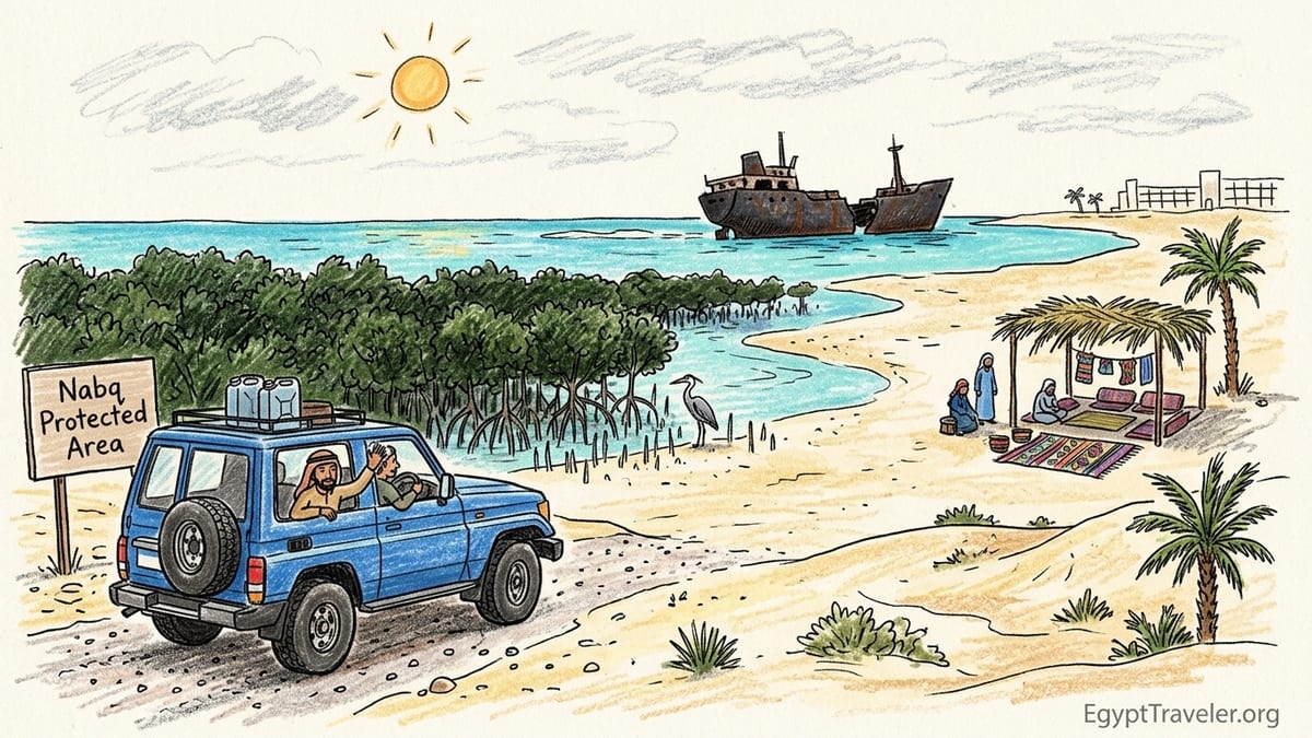
On a still April morning in Sharm el Sheikh, I left the polished marble lobby of my Nabq Bay hotel and stepped into a white Toyota Land Cruiser that looked far more at home in the desert than in the resort driveway. Within minutes we would leave the manicured strip of international hotels, beach clubs and shopping malls behind and enter a very different Nabq, one that exists not for sun loungers and cocktails but for mangroves, seagrass, dunes and a rusting German cargo ship stranded on the reef since 1956.
From Nabq Bay Resorts to a Real Protected Coastline
My day in Nabq Protected Area began with a 9:00 a.m. pickup from a hotel on the main road in Nabq Bay, about 20 kilometers north of central Sharm el Sheikh. I had booked through a local operator that works with licensed nature guides and 4x4 drivers, arranged the day before through the hotel’s small excursion desk. The same coastline is often marketed under one name, but it is important to understand that Nabq Bay, where the big resorts line the shore, is outside the boundaries of Nabq Protected Area. The reserve starts several kilometers further north, beyond the last continuous strip of hotels and beach clubs.
Our vehicle was a high-clearance Toyota Land Cruiser with working seatbelts and, crucially, air conditioning that had clearly been serviced recently. In the back were two large jerrycans of water, a cooler with bottled drinking water, a basic first-aid kit and an extra spare tire. My guide, Ahmed, introduced himself as a certified protectorate guide registered with the South Sinai protectorates office in Sharm. He explained that only authorized vehicles and guides are permitted inside the protected area and that trips are periodically checked at the entrance gate.
The drive from Nabq Bay to the official entrance of Nabq Protected Area took around 25 minutes. After the smooth dual carriageway that serves the resort district, our driver turned off onto a clearly signed track that led toward the sea. Here the asphalt ended. A police and ranger checkpoint sat in a low concrete building shaded by a corrugated metal roof. Ahmed took my passport, the vehicle license and a folded permit sheet to the ranger window, where we paid the daily entrance fee in Egyptian pounds. Entrance fees for Ras Mohammed and Nabq are periodically updated by the authorities, and on my visit in 2026 the amount was modest by international standards but clearly posted at the gate so there was no need to negotiate.
Beyond the checkpoint, the change in road conditions was immediate. The firm, beige gravel track undulated gently toward the coast, broken in places by ruts from previous rains and drifts of fine sand. Our driver dropped the speed to under 30 kilometers per hour. Outside, the modern resort skyline disappeared from view, replaced instead by low, dry hills rising to the west and a pale blue band of the Gulf of Aqaba on the horizon to the east. It felt like crossing an invisible border between the built-up Nabq Bay and a coast that still functioned largely on ecological, not commercial, terms.
Why Nabq Matters: Mangroves at the Edge of Their Range
As we crested a small rise, the coastline unfolded ahead of us and I saw the mangroves of Nabq for the first time. From a distance they appeared as a dark green fringe tracing the shore for several kilometers, broken only where pale sand spits reached into the sea. Ahmed explained that this is one of the most significant stands of mangroves in Egypt and that the mangrove belt here stretches for roughly 4.5 kilometers along the Nabq shoreline, forming what scientists describe as one of the northernmost substantial mangrove communities in the entire Red Sea and Indian Ocean system.
The trees here are predominantly Avicennia marina, commonly called grey mangrove. Mangroves are usually associated with tropical deltas and monsoon coasts, yet here they persist in water that is relatively warm and highly saline, in a region better known for arid mountains and coral reefs. Conservation plans prepared for the Egyptian Environmental Affairs Agency describe Nabq’s mangroves as a mono-specific fringe that has special significance because it grows so close to the climatic limit for the species. Their presence is a biological anomaly and a reminder that life often pushes against its expected boundaries.
Ecologically, Nabq’s importance extends beyond the trees themselves. Between the tangle of mangrove roots and the sandy lagoon floor lie wide beds of seagrass, including species such as Halophila stipulacea that are documented as abundant in the protected area. These seagrass meadows and mangrove roots together form some of the most important nursery grounds for fish along the Egyptian side of the Gulf of Aqaba. Regional conservation reports highlight Nabq as a key fishing area because juvenile fish shelter among the submerged roots and seagrass blades before moving out to deeper reefs as adults. The same mosaic also supports invertebrates, small crustaceans and mollusks that in turn sustain higher levels of the food web.
Above the waterline, the mangroves provide habitat and resting sites for coastal birds. Conservation material on Nabq notes that the area offers nesting and feeding opportunities for various waterbirds, including species of herons and ospreys. On my visit, under a hazy spring sky, I watched a single grey heron stand motionless on the edge of a shallow pool, then lift off with a slow, deliberate wingbeat. Gulls patrolled over the outer reef, but there were no large flocks or rare species in evidence that day. The absence of a photographic checklist did not make the mangroves any less impressive. The real story was the sheer improbability of this coastal forest existing at all in a corner of the Sinai better known for sun loungers and speedboats.
Walking Among Salt-Tolerant Trees and Their Hidden Nurseries
Our first stop inside the reserve was a low wooden platform overlooking a lagoon where the mangroves grew in scattered clumps rather than a solid wall. From this authorized viewing point, reached by a sandy side track that remained clearly within the designated route, I could approach close enough to see individual trees. The trunks emerged from the sand like pale, twisted legs, their bark a patchwork of silver and light brown. Around each trunk, the ground bristled with pencil-thin spikes about as long as my hand. Ahmed identified these as pneumatophores, specialized aerial roots that allow the trees to breathe in waterlogged, oxygen-poor sediments.
The tidal water around the mangroves was shallow, rarely reaching above my ankles when I walked at the very edge of the damp sand. Small fish, perhaps juveniles of commercially important species that later move to deeper reefs, flashed between the roots in quick, silvery bursts. Tiny crabs disappeared into holes as my shadow passed, and at one point I noticed tracks from a wading bird etched into the wet surface, a reminder that even when the wildlife is not obvious, the habitat is in use.
Ahmed stressed that the saline water here can be almost twice as salty as typical seawater in other parts of the world, yet the mangroves have adapted. Many Avicennia trees excrete excess salt through their leaves, which explains why some of the older leaves had a fine, gritty coating that tasted unmistakably of salt when I touched it to my tongue. The trees also time their gas exchange to coincide with lower temperatures to reduce water loss. In practice, what this meant for my visit was that the air immediately around the mangrove fringe felt slightly cooler than the open sand flats behind us, even as the sun climbed past mid-morning and the temperature reached into the low thirties Celsius.
From a conservation perspective, these trees and their root networks stabilize the shoreline. Environmental studies on Nabq point out that mangroves and associated seagrass help retain sediment and protect the coast from erosion. Standing there, watching small waves break harmlessly against the submerged roots instead of directly onto sand, it was easy to see how stripping away this vegetation would quickly change the coast. Eroded banks and cloudy water would not only undermine fish nurseries but also smother nearby coral reefs with suspended particles.
Across Arak Dunes and Desert Flats: Staying on the Tracks
Leaving the lagoon, our driver steered back to the main sandy track and followed it north, parallel to the shoreline. To our left rose low dunes known locally as arak dunes, named after the shrubby plants that help bind them together. These dunes are not tall, but they are mobile and fragile. The sand is fine and, in exposed patches where vegetation has been damaged, the wind has already carved small ripples that look delicate but can quickly evolve into larger blowouts if disturbed.
The desert vegetation here is sparse but surprisingly diverse once your eye adjusts. We passed clumps of salt-tolerant shrubs rooted in slight depressions where occasional runoff collects. Some carried minute, waxy leaves adapted to retain every possible droplet of moisture, others bore small, pale flowers that would be easy to miss from a moving vehicle. Ahmed pointed out a stand of arak shrubs that local Bedouin use for traditional toothbrushes by fraying the fibrous ends of twigs. Nearby, a few hardy grasses broke the monotony of sand, their roots acting like stitching that holds the dune surface in place.
At one point, another 4x4 appeared ahead, momentarily tempting our driver to cut a small corner off the main track to avoid soft sand. Ahmed intervened quietly but firmly. He reminded both driver and passengers that leaving the designated tracks is effectively off-road driving on a living surface. When a heavy vehicle crushes crust, shrubs or grass, it leaves wounds that take years to heal in this climate. Tracks often widen into multiple parallel scars as successive drivers try to avoid the roughest ruts, consuming more habitat in the process. In protected areas like Nabq, this can mean the difference between a functioning dune system and one that begins to unravel under wind erosion.
There are also safety reasons to respect the tracks. Soft patches of sand can swallow a vehicle up to its axles within seconds, particularly near hidden wadis that briefly carry water in winter rains. Recovery often requires another vehicle and aggressive acceleration, which only compounds the damage. During my visit, a ranger vehicle came past at one point, its occupants scanning the horizon as much as the tourists. Their presence was a visible reminder that the reserve is managed not only through signs and brochures but also through direct observation and, when necessary, intervention.
First Sight of the Maria Schröder Shipwreck
By late morning, the breeze off the Gulf of Aqaba had picked up, bringing a faint tang of salt and the sound of breaking waves. The track veered slightly closer to the shoreline, and ahead I noticed a dark, angular silhouette against the glinting water. As we drew nearer, the shape resolved into something unmistakably man-made: the corroded remains of a steel ship rising from the reef flat. This was the Maria Schröder, the German cargo vessel that has been stranded on Nabq’s reef since the 1950s.
Ahmed parked the Land Cruiser well back from the high-tide line in a sandy clearing already used by other vehicles, carefully avoiding any vegetation. From there we walked the last stretch on foot. The authorized visitor viewpoint is essentially the natural shoreline itself, a broad, gently sloping beach of sand and coral rubble. Signs in both Arabic and English indicated that visitors should not attempt to wade or swim out to the wreck, and that climbing on the structure is prohibited. The reasons are practical as well as ecological: the distance to the wreck crosses a shallow but uneven reef flat that can easily result in twisted ankles, cuts and damage to living coral.
Standing at the water’s edge, the ship appeared as two massive, rusted sections resting on the reef, separated by a gap where the midships structure has collapsed. Steel plates have peeled back like the layers of a broken tin, creating jagged silhouettes. Patches of white and light brown sea bird droppings streak the higher surfaces, evidence that at least some birds now use the wreck as a perch. The bow section leans slightly, while the stern still carries the outlines of what were once deck structures and cargo holds. Even after seven decades of waves and sun, the scale of the wreck remains impressive. It feels less like a museum piece and more like a stranded industrial animal slowly merging with its new environment.
The Verified Story of the Maria Schröder
Before visiting Nabq, I had heard several imaginative explanations for how the Maria Schröder ended up on the reef, ranging from wartime intrigue to deliberate scuttling. The verified history is more prosaic but no less compelling when you are looking at the real hull resting on living coral. According to shipping records and maritime histories, the ship was built in 1920 and later sailed under the name Maria Schröder after being sold to an owner in Hamburg in 1950. On 11 April 1956, while en route from Aqaba in Jordan toward West Germany, she ran aground on the reef off Nabq and could not be refloated despite attempts to tow her free.
Egyptian news features and diving community records agree on the basic outline: the vessel struck the outer reef, was stranded and over time broke in two under the combined stress of waves and corrosion. Cargo and equipment were removed where possible, but large sections of the hull remained. Today the wreck rests about one hundred meters offshore in what is now officially protected water inside Nabq Protected Area. Underwater photographs show that the lower sections are encrusted with coral growth and home to fish communities, while the upper structure continues to deteriorate in the sun and salt air.
From the authorized shore viewpoint, I could not see the underwater details, only the dark mass of metal above the waterline. This limitation felt appropriate. The wreck is not an amusement park installation but a historical artifact embedded in a living reef. Ahmed emphasized that walking out over the reef flat to get closer would crush coral heads that may be decades old, and that oil, paint and rust residues from the wreck itself have long since become part of the local ecological equation. Any additional disturbance from visitors climbing or removing pieces would only add to the damage.
Older photographs in local reports show visitors holding small chunks of rusted metal or bolts taken from the wreck as souvenirs. Current guidance from the protectorate authorities explicitly discourages this behavior. The days when tourists could chip off “trophies” from a shipwreck are, rightfully, over. During my visit, I did not see anyone approach the wreck directly. Most people stayed on the shore, using moderate zoom lenses to capture images that respected both safety and conservation rules.
Tourism, Conservation and Muzeina Bedouin Livelihoods
Over a simple lunch of grilled chicken, rice, salad and flatbread served under a shade structure of palm trunks and woven mats, Ahmed spoke about how tourism and conservation intersect in Nabq. Some of the shaded rest areas and small refreshment kiosks near the main visitor zones are operated by local Muzeina Bedouin families under arrangements overseen by the protected area management. The Muzeina, sometimes spelled Mazayna, are one of the main Bedouin tribes in South Sinai, with historical ties to fishing, herding and small-scale trade along this coast.
Conservation information produced by local NGOs and the authorities describes how, since the 1990s, management plans for Nabq were developed in consultation with the Bedouin community. Traditional activities such as artisanal fishing and grazing are regulated rather than banned outright, with an emphasis on sustainable practices. For example, specific zones and seasons are agreed for fishing, and some lagoon areas are restricted to allow fish nurseries to recover. Handcrafted goods like woven bracelets or small wooden items for sale at the rest area provide an additional, low-impact income stream that is compatible with the reserve’s objectives.
Tourism, meanwhile, is both a support and a stress. Entrance fees and licensed excursions help fund ranger patrols, signage, research and basic visitor facilities. Yet every extra vehicle brings noise, potential litter and physical wear on tracks and shorelines. During peak holiday periods, there is pressure to fit more activities into a single half-day excursion, from quad biking to camel rides and snorkeling. Conservation materials and responsible operators increasingly emphasize that not every activity is appropriate everywhere. High-speed quad bikes, for example, are best kept in designated areas outside the most sensitive dunes and mangroves.
Regarding seagrass and marine life, Ahmed mentioned that Nabq’s shallow lagoons and seagrass beds are known feeding areas for green turtles and, more rarely, dugong. Regional conservation plans support this, identifying Nabq as part of a network of habitats that these species depend on. I did not see turtles or dugongs during my visit, and Ahmed was clear that sightings are occasional and never guaranteed. However, knowing that the same quiet, shallow water that hides juvenile fish and seagrass meadows also supports such large marine herbivores gave additional weight to the need for controlled boat traffic, waste management and anchoring practices along this coast.
Real Conditions on the Ground: Heat, Facilities and Practicalities
No description of Nabq would be complete without acknowledging the basic realities of a day in the reserve. By midday, even in spring, the temperature had climbed to well above 30 degrees Celsius. The sun reflected off the pale sand and water with an intensity that made sunglasses, a wide-brimmed hat and high-factor sunscreen essential. Although the presence of a coastal breeze offered some relief, the air inside the stationary vehicle quickly became hot when the engine and air conditioning were turned off. Ahmed encouraged us to spend breaks in the shade structures rather than sitting in the car.
The walking itself was not technically demanding. Most of the time we strolled along flat sand or firm gravel, with only short scrambles up small dunes. However, even a modest 15-minute walk felt more tiring in the dry heat, especially when carrying camera gear and water. Closed shoes or sturdy sandals protected our feet both from hot surfaces and from sharp coral fragments mixed into the sand near the shore. Between stops, we drank from large refillable bottles of water that Ahmed had brought in a cooler, and he regularly reminded us to hydrate even when we did not feel especially thirsty.
Toilets inside Nabq Protected Area are limited and basic. At the main entrance area there were simple facilities, essentially cement cubicles with squat toilets and water provided from tanks rather than a central system. At one of the lunch stops, there was a similar arrangement, maintained by the family operating the rest area. Travelers who expect hotel-style bathrooms will be disappointed, but the facilities were reasonably clean and serviceable on my visit. Hand sanitizer and tissues from my own day pack proved useful.
Food was straightforward and satisfying rather than elaborate. Our tour included a set lunch prepared on-site, with grilled chicken and kofta, rice, tahini, salad and bread, along with bottled soft drinks and tea. Dietary requirements need to be communicated in advance, as there is no supermarket around the corner for last-minute changes. Shade was provided by low palm-frond shelters that cast a surprisingly effective shadow, and for those who preferred, the vehicle itself could serve as a windbreak. Photography was allowed throughout the main visitor areas, including the mangroves and the Maria Schröder wreck, but Ahmed asked us not to photograph close-ups of Bedouin people without explicit permission, especially women and children, which is in line with local cultural norms rather than a formal legal restriction.
The Takeaway: Nabq Versus a Standard Beach or Boat Trip
As we drove back toward the resorts of Nabq Bay in the late afternoon, dust trailing in the rearview mirror and the outline of hotel towers reappearing on the horizon, I found myself mentally comparing the day to a standard Red Sea beach or snorkeling cruise. Sharm el Sheikh offers no shortage of those: glassy-bottomed boats over nearshore reefs, large day boats with buffets and music, private beaches with floating pontoons and organized parasailing.
Nabq Protected Area offered something very different. Instead of a curated, controlled slice of reef brought to your fins or your sunbed, it presented a whole coastal system laid out along one protected shoreline. In a single day I had watched salt-tolerant mangrove trees filter seawater and shelter fish, seen seagrass beds and dunes share space with Bedouin rest areas, and looked out at a rusting German shipwreck that has spent more time aground than it ever did at sea. The experience was more demanding than a cruise. There was more heat, more dust, fewer creature comforts and no guarantee of dramatic wildlife sightings.
Yet it was precisely these constraints, combined with the tangible sense that my presence came with responsibilities, that made Nabq more memorable for me than many standard resort excursions. Standing on the shore, with the Maria Schröder on the reef and mangroves at my back, I felt acutely aware that this stretch of coast is surviving on a delicate balance between protection and use. For travelers willing to trade a little comfort for context, and a little convenience for connection, Nabq Protected Area delivers an ecological narrative that no poolside cocktail or crowded snorkel boat can match.
FAQ
Q1. How far is Nabq Protected Area from Nabq Bay and Sharm el Sheikh?
The entrance to Nabq Protected Area lies roughly 20 to 30 minutes by 4x4 north of the main resort strip in Nabq Bay, which itself is about 20 to 25 minutes by road from central Sharm el Sheikh, depending on traffic and hotel location.
Q2. Do I need a special permit or guide to visit Nabq Protected Area?
Access for visitors is usually arranged through licensed tour operators who work with authorized guides and drivers. At the entrance gate, rangers check permits and collect daily entrance fees, so it is simplest and most reliable to visit as part of an organized excursion rather than attempting to drive yourself.
Q3. What kind of vehicle is suitable for reaching the mangroves and the Maria Schröder wreck?
The road from Sharm to the reserve entrance is paved, but inside Nabq the tracks are sandy and uneven. A high-clearance 4x4 with an experienced local driver is recommended, as regular saloon cars risk getting stuck in soft sand or damaged by ruts and stones.
Q4. Can visitors walk out to or climb on the Maria Schröder shipwreck?
No. The wreck lies on a shallow reef flat some distance offshore, and visitors are expected to view it from the shore. Walking out would damage living coral and seagrass and can be dangerous due to sharp metal and uneven footing. Climbing on the wreck is prohibited for safety and conservation reasons.
Q5. Are there toilets, food and shade available inside Nabq Protected Area?
Basic facilities exist at key visitor points, including simple toilets, shaded rest areas and places where prearranged tours provide lunch. Facilities are modest and designed to have a limited footprint, so travelers should not expect the level of infrastructure found in resorts but will find essential services available.
Q6. What should I wear and bring for a day in Nabq?
Light, breathable clothing that covers shoulders, a wide-brimmed hat, sunglasses, sturdy sandals or closed shoes, and high-factor sunscreen are all important. Bringing your own reusable water bottle, tissues, hand sanitizer and a light scarf or buff for dust will make the experience more comfortable.
Q7. Is snorkeling part of every Nabq excursion?
Some itineraries include time to snorkel on designated reefs or lagoons, while others focus on mangroves, dunes and the shipwreck from shore. Because conditions, access rules and conservation priorities change, it is important to confirm with the operator in advance whether snorkeling is included and where it will take place.
Q8. What wildlife might I realistically see during a visit?
Common sightings include small reef fish in the shallows, crabs, wading birds such as herons and various gulls. Turtles and dugongs are occasionally reported in the seagrass beds but are not guaranteed, and the main attraction for many visitors is the mangrove ecosystem itself and the views of the Maria Schröder wreck.
Q9. How do entrance fees and tours support conservation in Nabq?
Daily entrance fees and licensed excursions help fund ranger patrols, basic infrastructure, research and community engagement with local Bedouin families. While figures and allocations can change, this user-based revenue is an important part of the financial foundation that allows the protected area to function.
Q10. How does Nabq compare to a typical Sharm el Sheikh boat or beach trip?
A visit to Nabq is usually less comfortable and more physically exposed than a resort beach or large snorkeling boat, but it offers a broader ecological perspective. Instead of focusing on a single reef site, Nabq shows how mangroves, seagrass, dunes and a historic shipwreck coexist along one protected coastline, making it a deeper and often more rewarding experience for nature-oriented travelers.